You are here

What is Soil Erosion? How Can Nuclear Techniques Help to Identify and Mitigate It?

Nuclear Explained
,

Soil erosion is a threat to agriculture and food production. It is the most significant contributor to land degradation, which affects 1.9 billion hectares of land worldwide, close to two thirds of global soil resources, threatening global food supply. (Image: A. Vargas/IAEA)

Soil erosion, the most common type of land degradation, is a process that removes the upper layer of soil, from which plants get most of their nutrients and water. When this fertile layer, called the topsoil, slides away, the productivity of land decreases and farmers lose a vital resource for growing food.

Unlike the wind or the sun, soil is a finite, non-renewable resource, which is degrading at alarming rates. Different types of land degradation are affecting approximately 1.5 billion people, particularly in developing countries. But soil has an unexpected ally — nuclear science. Nuclear techniques can help experts better understand the causes and the mechanisms of soil erosion, identify erosion hotspots and assess the impact of various land management practices on erosion rates, in order to make soil more resilient to the effects of climate change and to protect soil for the future.

Using nuclear technology, such as the fallout radionuclide (FRN) technique and the compound specific stable isotope (CSSI) technique, the IAEA helps to assess soil erosion, so that the right strategies to protect soil can be implemented. Jointly with the Food and Agriculture Organization of the United Nations (FAO), the IAEA helps countries strengthen capacities in using nuclear and isotopic techniques to combat soil erosion, preserve soil resources and support sustainable agricultural production.

What are the causes? What are the effects?

(Image: A. Vargas/IAEA)

Although soil erosion is a natural process and it occurs on all continents, human activities have greatly accelerated it. In general, soil erosion is more common on steep, sloping land. It is often caused by natural factors, including strong wind or heavy rains; however, unsustainable human activity, such as deforestation or improper land management, can accelerate this process by two to three orders of magnitude.

Soil erosion makes land vulnerable to the loss of fertile topsoil and this, together with the losses of associated nutrients and chemicals, is a threat to agricultural production, food security and the environment, mainly water resources. Soil is the source of as much as 95 percent of all agricultural production, so its health and availability impact the quality and quantity of our food. Approximately a quarter of the world's population directly depends on food produced on degraded land, and every year the rate of degradation is increasing, leading to the annual loss of millions of hectares of land worldwide.

Eroded soil also affects water quality and aquatic life, since soil can be transported by runoff to water courses, such as rivers and lakes, clogging water reservoirs and causing the nutrients washed from the fields to accumulate in water and lead to algae outbreaks. This jeopardizes water quality and harms the habitats of aquatic life. In addition, even in larger reservoirs, such as oceans and seas, sediments may accumulate in large enough quantities to increase turbidity and reduce visibility in nearby waters, further threatening the sustainability of aquatic ecosystems and often leading to die-offs among the flora.

Other consequences of soil erosion include degradation of ecosystem functions, amplified risks of landslides and floods, significant losses in biodiversity, damage to urban infrastructure and, in severe cases, displacement of human populations.

How can nuclear techniques help?

Eroded soil may not replenish for generations, which is why it is important to assess soil erosion and deposition rates, as well as to improve land management and implement soil conservation measures. This is where nuclear techniques can help. The FRN and CSSI techniques are most used to tackle soil erosion. The FRN techniques help to assess and quantify soil erosion rates, while the CSSI method identifies areas most affected by erosion.

Based on the results of these nuclear applications, soil conservation measures can be implemented, such as terracing, contour cropping, strip cropping, minimum tillage, no tillage, mulching, cover crops, erosion ridges and erosion furrows. See examples from Madagascar and Uganda.

Fallout radionuclide (FRN) method

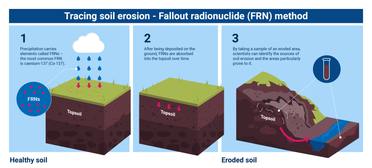
Fallout radioniclides (FRNs) are deposited on the ground with rain. The amount of FRNs in soil is very small and harmless to humans, but measuring the precise quantities with nuclear techniques can help to estimate soil erosion rates. (Image: A. Vargas/IAEA)

FRNs are dispersed all over the world. The most common FRN is caesium-137 (Cs-137), which was released primarily during nuclear weapons testing in the 1950s-1960s. It was dispersed in the atmosphere all over the world, then was deposited by rain and incorporated into topsoil over time.

Although the amount of FRNs in soil is very small and harmless to humans, it can be measured by sensitive gamma spectrometry, and its quantities can be used to estimate soil erosion rates. When the topsoil is affected by erosion, the Cs-137 concentration is reduced, and as a result, where eroded soil is deposited, Cs-137 concentration is increased. Tracking the FRN redistribution allows experts to determine how much soil has been removed from one location and deposited in another location. To interpret the data, a site that has not been impacted by erosion or deposition needs to be identified. This site, where the amount of FRN has been reduced only by radioactive decay, represents the baseline. The eroded and deposition sites are then compared to the reference site to calculate the amount of eroded or deposited soil.

Apart from Cs-137, two other fallout radionuclides are also used for soil erosion tracking, lead-210 (Pb-210) and beryllium-7 (Be-7).

Using FRNs for soil erosion assessment is more convenient, cheaper and less labour intensive than conventional methods, such as volumetric measurements of soil removal or measurements of sediment export at spatial scales on different-sized land plots. The FRN techniques are useful especially in studying the impact of land use on soil erosion and the efficiency of soil conservation measures. This information is indispensable for developing soil conservation strategies, selecting suitable conservation measures and implementing soil conservation programmes. 

Compound specific stable isotope (CSSI) method

Scientists can track the presence of stable isotopes, such as carbon-13, in the soil to determine soil erosion hotspots and identify the impact of different land uses and crops on the distribution of erosion. (Image: A. Vargas/IAEA)

The FRN techniques cover many, but not all dimensions in soil erosion assessment. For this reason, when identifying the origin of sediments and erosion hotspots in larger areas, such as watersheds, compound-specific stable isotopes (CSSI) method is used — it was designed specifically for these purposes.

The CSSI technique measures the carbon-13 (C-13) stable isotope to distinguish different sources of soil organic matter. This is because each plant has a different C-13 signature, which is preserved in the soil when plant tissues decay. This enables identification of ecosystems and land uses, which contributes to soil organic matter. C-13 analysis requires constituents of plant tissue, which are stable and do not decompose in soil. Fatty acids, originating from plant roots, are most suitable for this purpose. When plant tissues decay, the fatty acids become part of the soil organic matter. They have unique stable isotope signatures, which can be analysed and used like fingerprints.

Using the CSSI technique, scientists match the “fingerprints” of the compounds in the soil to those in the ecosystems occupying the selected study area. By taking a sample of an eroded area, scientists can identify the sources of eroded soil and sediment in water reservoirs, as well as the areas particularly prone to it. This information is valuable for precise targeting of soil conservation measures. See an example of a project in Myanmar.

What is the role of the IAEA?

Stay in touch

Newsletter