You are here

Nuclear Techniques Reveal Depth of Soil Erosion in Uganda

,
The mountainous agricultural region in Uganda’s southwestern highlands are affected by soil erosion

The mountainous agricultural region in Uganda’s southwestern highlands are affected by soil erosion. (Photo: E. Fulajtar/IAEA)

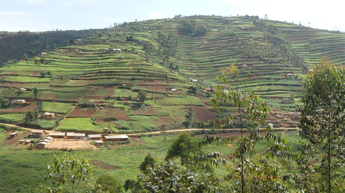
The livelihoods of millions of Ugandans are rooted in the highlands – the mountainous or elevated regions of the East African country. Scattered along the eastern and western borders, the highlands of Uganda are home to about 40 per cent of the country’s 46 million people. These regions play a significant role in agriculture, which is the main source of income for many Ugandans, including for 70 per cent of working women, according to the country’s Ministry of Agriculture, Animal Industry and Fisheries. These regions are also recognized as one of the key hotspots where land degradation, due to soil erosion, is rampant.

The vital grounds that sustain life were the subject of a study recently completed by the National Agricultural Research Laboratories (NARL) in the capital Kampala with support from the IAEA, in partnership with the Food and Agriculture Organization of the United Nations (FAO). Experts assessed erosion rates in the highlands using nuclear techniques, to inform policy makers, farmers and other stakeholders on actions to take to reverse or at least reduce land degradation. “Through the Technical Cooperation Programme, NARL is an institute under the National Agricultural Research Organization, has benefited in developing capacity for erosion research since 2013. During 2016-17, the staff at NARL completed training in soil sampling, analysing the caesium-137 (Cs-137) radionuclide in soil, which can serve as an erosion tracer, and using relevant equipment,” said Valentina Varbanova, IAEA Programme Management Officer.  

The study included sampling slope transects across terraced fields in the Rubanda District in the southwestern highlands. The results revealed that most of the terraces were eroded – having lost about 12.6 cm of topsoil in the last 60 years – indicating that the effects of traditional terracing techniques to conserve soil on steep slopes of Uganda highlands are insufficient.

“The highlands are densely populated and intensively exploited by agriculture because they receive high rainfall and have moderate temperatures, convenient for settlement,” said Emil Fulajtar, a soil scientist at the Joint FAO/IAEA Centre of Nuclear Techniques in Food and Agriculture. “The land is dominated by small family farms on steep slopes of about 30 to 40 degrees.” As the rain can easily wash off the topsoil, the most fertile part of the soil profile, these areas are threatened by land degradation.

Strongly degraded fields lose their production potential and are abandoned. (Photo: E. Fulajtar/IAEA)

Nuclear techniques for assessing and validating measurements

Researchers from Uganda, Rwanda and China had evaluated soil erosion in the country, most recently in 2017, using a conventional non-nuclear modelling method. The results obtained by the Universal Soil Loss Equation (USLE) – a mathematical model that describes the long term average annual rate of erosion – suggested that the mean rate of soil erosion in the highlands is between 10 and 100 tonnes per hectare per year (t/ha/y), commonly reaching more than 100 t/ha/y. The highlands’ rates exceeded the country’s average of 3.2 t/ha/y and highlighted the need for soil conservation measures to ensure sustainable agricultural production. The estimated rates provided by those models lacked validation that needed to be obtained by field measurements.

Using Cs-137 radionuclide as a tracer, researchers sampled 41 soil profiles to measure erosion rates. “Only four soil profiles were stable – showing neither erosion nor deposition – and six profiles showed deposition, where sediments from erosion have accumulated, altering the shape of the land,” Fulajtar said. The remaining 31 profiles were eroded, with a maximum erosion rate of 96 t/ha/y and average rate of 30.4 t/ha/y. The field measurements obtained with Cs-137 supported estimates calculated by the USLE. The Cs-137 method (see Fallout radionuclides to assess soil erosion) has been applied in over 70 countries through the IAEA’s technical cooperation programme and coordinated research projects to measure erosion rates and validate the efficiency of conservation methods.

Because of the discrepancy between the number of deposition and erosion profiles, Fulajtar concluded that “most eroded soil was removed from the cultivated terraced slopes and ended up on foot slopes and valleys or as suspended sediment in rivers and lakes,” which subsequently affects the quality of water resources.

Since the early 1960s – when Cs-137 was released into the atmosphere from nuclear weapons tests and deposited on the Earth’s surface – until the time of sampling in 2018, more than 60 per cent – or 12.6 cm – of the cultivated topsoil layer had been lost to erosion. Additional soil conservation measures are needed, Fulajtar said, suggesting three promising approaches: no-tillage land management to reduce soil erosion caused by rainfall, while increasing the amount of water that infiltrates into the soil; switching to crops with higher soil conserving efficiency, for example from cassava, sorghum, peas and beans to wheat or other densely seeded crops; and erosion ditches to stop runoff and the displacement of sediments.

The IAEA studies were reported in Uganda's National State of the Environment Reports to help guide decision makers on environmental issues. “Policy makers need information on the rates of soil erosion, its effect on people’s livelihood and the effectiveness of the different soil conservation measures to enable them to pass relevant policies, by-laws and ordinances for the sustainable use of natural resources on which 4.2 million smallholder farming households derive their livelihood,” said Crammer Kayuki Kaizzi of NARL. “Reduced soil erosion through better soil and water management will result in reduced siltation of rivers, lakes and other open waters to benefit the environment, smallholder farmers and people living in rural areas. Access to quality water is important since the majority rely on unprotected springs and open wells for domestic use.”

Rill erosion, when runoff water forms small channels, is abundant at some fields in Uganda’s highlands. (Photo: E. Fulajtar/IAEA)

Stay in touch

Newsletter