• English
  • العربية
  • 中文
  • Français
  • Русский
  • Español

You are here

Nuclear Techniques Help Scientists Save Myanmar’s UNESCO Biosphere Reserve

,

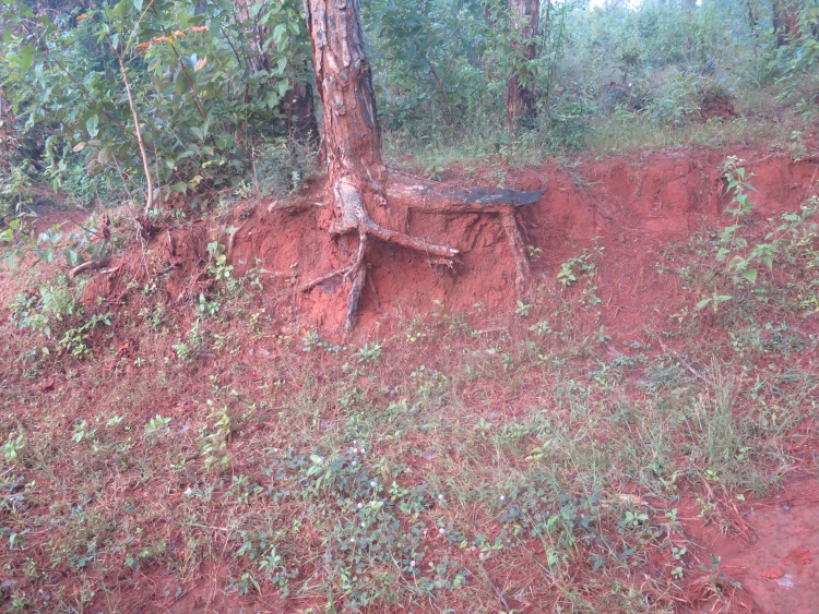
Nyaungshwe, Myanmar – Ongoing deforestation around Inle Lake is leading to significant soil erosion in one of its major tributaries, causing soil accumulation in the lake and threatening the fragile ecosystem of this UNESCO Biosphere Reserve. This conclusion of a study using nuclear techniques, which have also identified the exact sources of the soil erosion in the Kalaw watershed, will enable local forestry officials to target their conservation efforts in the areas most susceptible to erosion.

Conservation and the use of the new data to educate local people about the consequences of illegal logging and the increased use of the lake as a floating vegetable garden will help save Inle, said U Sein Tun, park warden at the Forest Department in Nyaungshwe, the biggest town on the lake. The erosion research, which was completed last month, was carried out by Myanmar’s Forest Research Institute and supported by the IAEA and the Food and Agriculture Organization of the United Nations (FAO).

The erosion site in the Kalaw water shed. Much of the soil missing from the hillside ended up in Inle Lake. (Photo: M. Gaspar/IAEA)

It has used two nuclear techniques to characterize soil erosion.

Fallout radionuclides such as caesium-137 (Cs137), lead-210 (Pb210) and beryllium-7 (Be7) are used to assess soil erosion and sedimentation processes. These radionuclides are strongly fixed to soil particles and are not taken up by plants. During erosion and deposition processes they move with the soil particles and can be used to trace soil redistribution over large areas and extended periods of time.The results in the Kalaw watershed have shown that each hectare of land that lost its forest cover 15 years ago has lost 26 tons of soil every year since, said Cho Cho Win, the research officer who headed the study. For land that was deforested and cultivated 40 years ago, the soil loss has been a whooping 40 tons per hectare per year. “By contrast, on comparable areas where the forest cover was left intact, there has been no erosion whatsoever,” she said.

Erosion researcher Cho Cho Win (l) and a local forestry official looking at erosion sites around Inle Lake in central Myanmar. (Photo: M. Gaspar/IAEA)

The results have shown significant soil losses at the upper slopes and soil accumulation at lower locations, closer to the lake. This indicates that significant sediment discharges into the lake continue to occur, Cho Win said.

Another method, the compound specific stable isotope (CSSI) technique, was used to identify the origins of erosion by analyzing the makeup of sediments along the river, right until its confluence in the lake. CSSI is based on the measurement of carbon-13 isotopes of specific organic compounds of plants in soil. The makeup of carbon-13 is unique for each compound, so a carbon-13 analysis reveals the origin of the eroded soil. By linking carbon-13 fingerprints of land use to the sediment in deposition zones, this technique is useful in determining the sources of eroded soil and in identifying areas prone to soil degradation.

Reversing the environmental degradation of Inle Lake brought about by soil erosion is a key objective of not only for the local forestry office but also for the regional government of Shan state as well, Sein Tun said. Chief Minister Linn Htut has resolved to head the commission that is tasked with improving the condition of the lake.

“The research by Ms Cho Cho Win is an important contributor to our efforts,” Sein Tun said.

Stay in touch

Newsletter